12th International FIG Workshop on LADM & 3D LA
The 12th International FIG Workshop on the Land Administration Domain Model & 3D Land Administration will take place in Kuching, Malaysia, 24-26 September 2024. It will be a joint event together...

The 12th International FIG Workshop on the Land Administration Domain Model & 3D Land Administration will take place in Kuching, Malaysia, 24-26 September 2024. It will be a joint event together...
Geo Week is the premier event for increased integration between the built environment, advanced airborne/terrestrial technologies, and commercial 3D technologies. It was created as a response to the changing needs of built world...

Inertial Labs and Sony have joined forces to develop an advanced Lidar system tailored for Sony's Airpeak drone. This collaboration aims to enhance drone capabilities in applications such as surveying,...
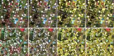
The practice of identifying and monitoring an area's physical features by measuring its reflected and emitted radiation from a distance is known as remote sensing (typically from satellite or aircraft). Researchers can "sense" facts about the Earth by using special cameras to acquire remotely sensed photos. Remote sensing is a fascinating field that revolves around the acquisition of Earth-related information without direct physical contact. It typically yields either point cloud data or imagery, both of which...

In the ever-evolving landscape of climate change, geospatial science emerges as a key player in navigating the complexities of our transforming world. The European Association of Aerial Surveying Industries (EAASI)...
From drones and satellites to airborne-based sensors and Lidar, advances in remote sensing and geospatial information science are driving the development of innovative methods for data acquisition, processing and maintenance....

The fourth edition of Geo Connect Asia (GCA), celebrated as the region's premier trade event and conference for the geospatial, positioning and remote sensing industries, truly delivered during its two-day...

Despite some uncertainty, there is renewed interest in drones, and remote sensing technologies are being embraced by smaller survey companies. Read these and other findings from our annual industry survey!...
This site uses cookies. By continuing to use this website, you agree to our Cookies Policy. Agree