Linda Foster
Linda Foster oversees Esri’s worldwide strategic vision for land administration and surveying. With 20 years of experience working in the land and resource industry, she is a registered professional land...

Linda Foster oversees Esri’s worldwide strategic vision for land administration and surveying. With 20 years of experience working in the land and resource industry, she is a registered professional land...

There are indications that today’s technological advances are putting a fully operational multipurpose cadastre within reach, following decades of a global vision and small-scale progress towards a comprehensive map-centric land...
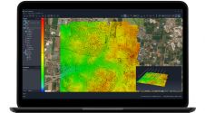
SimActive has unveiled the enhancement of Correlator3D for improved cloud environment productivity. With Correlator3D’s distributed processing capabilities, clients can seamlessly scale their processing in line with operational needs. The challenges...

Airbus has announced a data-sharing agreement with satellite imagery purveyors Planet, along with a project to deliver a geoinformation platform and pipeline for the Thai government. The depth and breadth...

DigitalGlobe has released satellite imagery and data of the wildfires in California through their Open Data Program. The publically released imagery is for Ventura, California, and the surrounding communities and...

The calls for assistance started days before Hurricane Harvey came barreling across America’s doorstep this summer. First responders and government officials needed answers to prepare and protect communities. Remotely sensed...
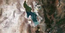
Utah’s Great Salt Lake dropped to its lowest recorded water level last month as a megadrought persists across the US southwest, forcing the fast-growing city to curb its water use....

In September 2015, the World Health Organization announced that there had been no cases of wild poliovirus in Nigeria since 24 July 2014 and a full 12 months had subsequently...
Proteus, a provider of satellite derived mapping, bathymetry and geospatial products, has strengthened its professional satellite imagery procurement service by signing up as a reseller with international satellite imagery provider Airbus...

Following Cyclone Pam, Airbus Defence and Space has acquired Pléiades and SPOT 6 & 7 imagery over the island nation of Vanuatu to support the International Charter and Copernicus Emergency...
This site uses cookies. By continuing to use this website, you agree to our Cookies Policy. Agree