Photogrammetry Aids River Restoration
Structure-from-Motion photogrammetry and GIS are being used to chart the success of a river restoration project in Northern England. Many of the world’s rivers are degraded as a result of...

Structure-from-Motion photogrammetry and GIS are being used to chart the success of a river restoration project in Northern England. Many of the world’s rivers are degraded as a result of...

Aerial photography from Bluesky is being used to identify changes in sediment movement in upland river courses, to help assess the risk of flash flooding. In research centred on the English...
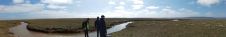
Coastal and estuarine saltmarsh has long been recognised as having key physical, ecological, and recreational value, acting as sediment and nutrient traps and as natural coastal protection structures functioning as...

This survey in southern France confirmed the suitability of UAV Lidar for mapping shoreline changes in the context of erosion and drinking water availability. The French Mediterranean coast is a...

The Landsat 8 Earth-observing satellite has marked being five years in orbit. In that time, it has racked up 26,500 orbits around the planet, 1.1 million "scene" captures, and an...

The United Nations Education, Scientific and Cultural Organisation (UNESCO) with EOMAP have launched an interactive tool providing access to detailed global water quality indicators from an archive of Earth Observation...

While 70% of the Earth is covered by water, very little of it has been surveyed so far (Mars, Venus and the Moon are better surveyed). The techniques for doing so...

International aquatic remote sensing company EOMAP recently showcased its unique contribution to the world's first 3D habitat map of the Great Barrier Reef (GBR) at the International Forum on Satellite-Derived...

The 3D Geospatial Data Processing Group from Heidelberg University in Germany is conducting studies of rock glacier dynamics in a high-Alpine permafrost environment. The team is utilizing a RIEGL VZ-2000i terrestrial laser...

Teams from the US and the UK have successfully completed scientific fieldwork in one of the most remote and hostile areas of West Antarctica – coinciding with the 200th anniversary...
This site uses cookies. By continuing to use this website, you agree to our Cookies Policy. Agree