Digital twins for a sustainable world
How can city digital twins support the attainment of SDG11? They can be used to manage infrastructures (e.g. roads, transportation and public services, smarter energy grids and water networks), support...
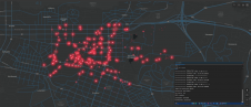
How can city digital twins support the attainment of SDG11? They can be used to manage infrastructures (e.g. roads, transportation and public services, smarter energy grids and water networks), support...

The organizers of Geo Week have released a preview of two keynote sessions for 2024: 'The Bright Future Ahead: Navigating AEC, 3D, and Geospatial Innovation and Change', and 'Geospatial for...
Calling all geospatial professionals! You’ve no doubt been involved in inspiring projects and applications that leverage innovative reality capture methods and advanced technologies. In the spirit of knowledge exchange, why...

Canada's geospatial community is gearing up for the country's inaugural national geospatial exposition. The GoGeomatics Expo is scheduled to take place from 6-8 November at the iconic Calgary Stampede grounds....

The curtains have fallen on Intergeo 2023. What were the key takeaways from the vibrant three-day event in Berlin? From 10-12 October, a diverse array of experts and enthusiasts from...

Leica Geosystems, part of Hexagon, has officially announced the Leica BLK2GO PULSE. This innovative first-person laser scanner merges state-of-the-art Lidar sensor technology with the iconic Leica BLK2GO design, representing a...

Digital Twins (Intergeo Edition) To tie in with the Intergeo event, this edition will reflect on the practical digital twin-related challenges in the geospatial domain. While the concept of the digital twin has been...
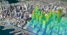
Thanks to the ability of digital twins to provide insights into the reality of present conditions and the impacts of future scenarios, they have the potential to revolutionize the planning...
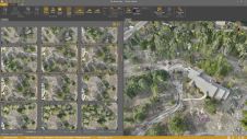
Virtual Surveyor has added drone photogrammetry capabilities to the latest release of its popular Virtual Surveyor smart drone surveying software. The new Terrain Creator app photogrammetrically processes drone photos to...
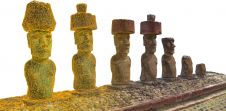
In this interview, John Ristevski, chairman and CEO of CyArk, takes us on the organization’s 20-year journey of digitally preserving cultural heritage sites. Today, the company uses advanced technologies such...
This site uses cookies. By continuing to use this website, you agree to our Cookies Policy. Agree