Found 1583 results
Sort by

Virtual Geomatics And Sanborn

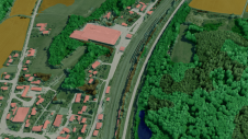
Virtual Geomatics (TX, USA) and Sanborn have agreed to procure Virtual Geomatics VG4D software solutions for Sanborn\'s LiDAR operations. The Virtual Geomatics\' software solutions will initially be deployed for production...

Read more

Vexcel Virtual Earth Appliance

Vexcel Corp. (CO, USA) has made available the Virtual Earth Appliance, designed to bring the data and functionality of the Microsoft Virtual Earth Internet service to the offline customer. The...

Read more

Leica Virtual Explorer 3.1

Leica Geosystems Geospatial Imaging (GA, USA) has released Leica Virtual Explorer 3.1. This version offers several enhancements, such as new tools for third-party integration and additional texture and navigation options....

Read more

MSN Virtual Earth Released

Microsoft Corp. (WA, USA) has announced beta availability of MSN Virtual Earth. The service enables users to search, discover, explore, plan and share information and activities relevant to specific U.S....

Read more

Reality Modelling Goes Mainstream

At Bentley System’s annual conference for infrastructure thought leaders, CEO Greg Bentley presented a keynote speech. He stated that since Bentley Systems’ acquisition and assimilation of ContextCapture software in 2015, the...

Read more

Everyday Reality Demonstrated

Yesterday (16 July) was the last day of the exhibition on the second floor. Many businesses showed their products and services, allowing the congress visitors to touch the products and...

Read more