SimActive Adds Multiple New Features to Correlator3D
SimActive has announced the release of Correlator3D version 8.6. The new version includes multiple new features, such as the use of intensity data from LAS files for image registration, the...

SimActive has announced the release of Correlator3D version 8.6. The new version includes multiple new features, such as the use of intensity data from LAS files for image registration, the...
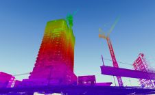
When it comes to 3D modelling for construction, what are the advantages and disadvantages of photogrammetry versus Lidar in terms of accuracy, complexity and cost? Breaking away from laser measurement...

A recurring sustainable issue faced by the architecture, engineering and construction (AEC) industry is that of green buildings. The global market for green construction is projected to reach US$364.6 billion...

TatukGIS recently implemented support for geological 3D maps for incorporating multiple, vertically spaced digital elevation models and other layers in the same map project. This was done in response to...
Large amounts of personal data, such as faces and number plates, are collected during mobile mapping. Receiving consent from individuals for large-scale data collection is not feasible but is required...

YellowScan, a market leader in UAV Lidar mapping solutions, has announced a new distribution partnership with Beijing MapCore Technology. MapCore is known as a company with extensive experience in survey...

Earth observation company 4 Earth Intelligence (4EI) is partnering with Airbus Defence and Space to release the power of Airbus very high resolution satellite imagery for applications such as climate...

It is an exciting time for geospatial professionals. The data that can now be obtained using unmanned aerial vehicles (UAVs, or drones) opens up previously impossible opportunities in many different...

Lidar mapping based on unmanned aerial vehicles (UAVs or ‘drones’) can generally be thought of as a close-range version of manned airborne laser scanning. In brief, lower mobilization costs and...

According to Global Market Insights, the worldwide Lidar in mapping market is expected to exceed US$4 billion by 2026. The rising demand to reduce the risks associated with natural disasters such...
This site uses cookies. By continuing to use this website, you agree to our Cookies Policy. Agree