UK Storm Surge Impacts Mapped Using UAS
One year on from the biggest UK storm surge for 60 years, new aerial photos have revealed details of breaches to the natural and manmade coastal defences on part of...

One year on from the biggest UK storm surge for 60 years, new aerial photos have revealed details of breaches to the natural and manmade coastal defences on part of...

European Space Agency (ESA)’s ice mission has been used to create a new gravity map, exposing thousands of previously unchartered ‘seamounts’, ridges and deep ocean structures. This new picture of...

Snow-covered deserts are rare, but that is exactly what the Moderate Resolution Imaging Spectroradiometer (MODIS) on NASA’s Aqua satellite observed as it passed over the Taklimakan Desert in western China...

As part of an ongoing project to bring to city managers, citizens, tourists and others geo-data of the Golden Horn area of Istanbul, Turkey, the authors designed a geo-database accessible...
In soil and sediment studies, geophysical mapping is often used as a prerequisite to focus or guide traditional sampling and coring of the locations of interest. This way, synoptic and...
Mountains notice changes in air pressure too. Recently, USGS scientists working on the Slumgullion Landslide in Colorado, US, have found that periods of low atmospheric pressure can trigger landslides. Landslides...
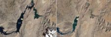
In August 2010, Lake Mead reached its lowest level since 1956. Two images from the Thematic Mapper on the Landsat 5 satellite show some of the stark changes on the...
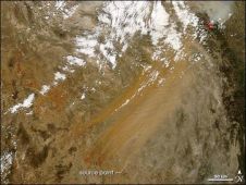
A method for predicting dust and sandstorms using infrared satellite images has been developed by researchers based at the University of Pittsburgh (USA). They can determine when conditions are ripe...
Years of environmental neglect and deforestation on CFB Gagetown have unfortunately caused sedimentation in the more than 2,400km of streams on the base. In an effort to control this and...
Carlson Software’s Natural Regrade fluvial geomorphic landform design software will be used to teach at the Complutense University of Madrid beginning January 2010. Natural Regrade’s innovative GeoFluv™ fluvial geomorphic landform...
This site uses cookies. By continuing to use this website, you agree to our Cookies Policy. Agree